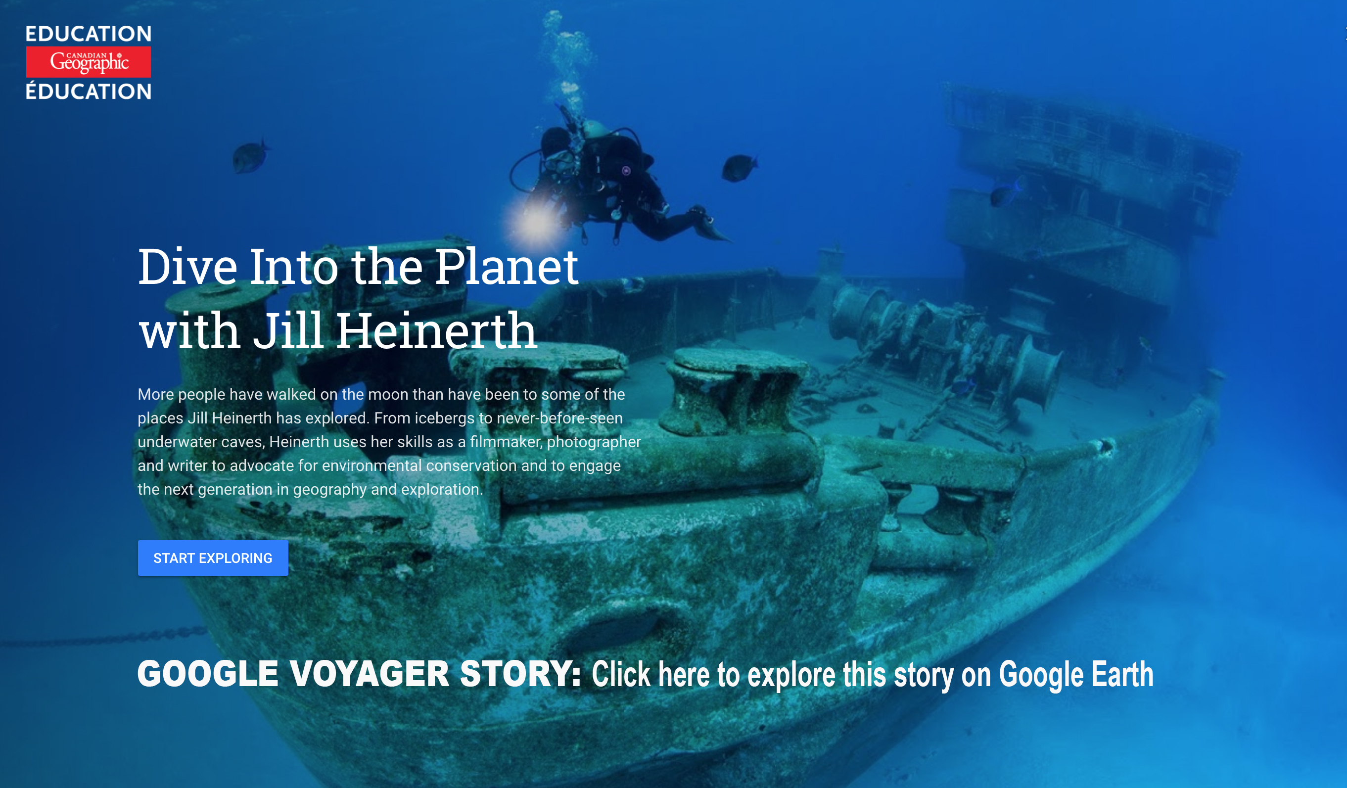
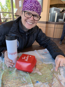
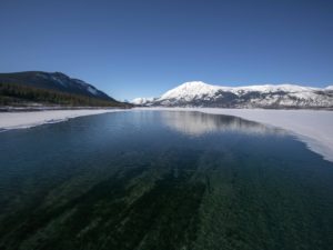
From the Arctic to the Pacific, Atlantic and Great Lakes/St. Lawrence Seaway, Canada has four coasts. Canada’s water geography includes over 200,000 kilometers of coastline, more than any other country in the world. 8 percent of our territory is covered by lakes – more lake area than any other country in the world. We possess 9 percent of the world’s renewable fresh water, yet only half a percent of the global population. A Circle of Blue commissioned study found that for two-thirds of us, key issues of concern include water pollution and access to safe drinking water.
Our waterways offer tourism, recreation and commercial fishing. Our abundant reserves support the production of goods. Water irrigates our crops and bolsters the food and beverage industry. Flood control, drought mitigation, environmental purification and reserves for biodiversity; we ask a lot of our water geography.
And the health of Canadians is significantly affected by accessibility to clean, safe water. According to Environment Canada, each year 90,000 Canadians fall ill from waterborne pathogens and 90 people die. As many as 75% of water systems on First Nations reserve communities have significant threats to the quality and quantity of drinking water. In the past several years, 25 percent of Canadian municipalities have experienced periodic water shortages. People do not know where their water comes from or how they can better safeguard both quantity and quality.
As Canadians, we have an opportunity to lead the world by our example. We can live in peace and harmony with our water planet. This website celebrates the beauty of our waterways and hidden underwater vistas and brings to light water issues across our land.

Click the map points for detailed stories. This page is being constantly updated as I make my journey through Canada’s water stories in 2018 and 2019.

Ultimate Travel Tips – For Divers

By | All Posts, Into The Planet Book, Royal Canadian Geographical Society, Underwater Canada, Underwater Photo and Video | No Comments

I have spent a lifetime traveling the globe on expeditions and filming projects. This is installment three of my top 100 travel tips to make your journey more relaxed and earth-friendly. 1. Camera Rinse – use a soft cooler or inflatable cooler to protect your camera on and off the boat. It will double as a private gear rinsing tank. 2. Luggage Protection – Coolers are lighter than Pelican hard cases and equally protective. 3. Inflatable Padding – An inflatable camping pillow serves well as protective padding for sensitive gear and camera parts. 4. Wing Safe – If you are…

Read More

Ultimate Travel Tips – Toiletries and Extras

By | All Posts, Into The Planet Book, Royal Canadian Geographical Society, Underwater Canada, Underwater Photo and Video | No Comments

I have spent a lifetime traveling the globe on expeditions and filming projects. This is installment six of my top 100 travel tips to make your journey more relaxed and earth-friendly. Toiletries 1. Small toiletries – Use contact lens cases for vitamins, creams, hair gels, and lotions. These little containers each carry a week’s supply of anything you need, and they won’t spill. 2. Toothpaste – To minimize taking a whole tube, make small dots of toothpaste and allow them to dry. Store them in contact lens cases. Put a toothpaste dot in your mouth and brush up. 3. Resist…

Read More

Ultimate Travel Tips – Clothing Choices

By | All Posts, Into The Planet Book, Royal Canadian Geographical Society, Underwater Canada, Underwater Photo and Video | No Comments

I have spent a lifetime traveling the globe on expeditions and filming projects. This is installment five of my top 100 travel tips to make your journey more relaxed and earth-friendly. 1. Belt – I always wear a lightweight webbed belt. Beyond holding up my pants, I can use it for yoga stretches. 2. Wool – The benefits of wearing merino wool are unsurpassed. This magic fabric is incapable of holding human body fat that causes odor. You can wear merino for a month of sweating, and the clothing will not smell. It is great for warm and cold weather….

Read More

Ultimate Travel Tips – On the Ground

By | All Posts, Into The Planet Book, Royal Canadian Geographical Society, Underwater Canada, Underwater Photo and Video | No Comments

I have spent a lifetime traveling the globe on expeditions and filming projects. This is installment four of my top 100 travel tips to make your journey more relaxed and earth-friendly. 1. The Best Gear – My favorite piece fo gear is waterproof, silicone roll-top bag. I can use it as a pillow. I can do a load of laundry in it by filling it with water and a little soap. I can also use that water-filled laundry bag as a substitute for free weights in the hotel or camp. 2. Flashlight Safe – I use an old empty waterproof…

Read More

DIVE IN NOW

NUNAVUT

Arctic on the Edge – How Changing Sea Ice is Affecting the People and Wildlife of the North

Under Thin Ice – Documentary Coming Soon!

Crack***JILL6280 copy

NEWFOUNDLAND & LABRADOR

Colorful Cas 2888eBELL ISLAND, NEWFOUNDLAND

Few people know that Bell Island, Newfoundland, Canada was directly attacked during World War II. In 1942, German U-boats twice raided the island in an attempt to disrupt the flow of high-grade iron ore being transported from mines on the island. This ore was used to supply steel critical to the war effort. Germans knew that if they could disrupt the flow of shipbuilding materials, even temporarily, then the Allied war efforts would be seriously affected. In two separate attacks, U-boats sunk the SS Saganaga and SS Lord Strathcona followed by the SS Rose Castle, Free French vessel PLM 27 and the loading wharf on Bell Island. In all, 70 men were killed. The sheer temerity of the attack awakened North Americans that they were on the front lines of the Battle of the Atlantic. A short distance from shore, experienced divers can plunge into the cold water to explore these remarkable shipwrecks that have become magnets for biodiversity.

CasCross5374lwm
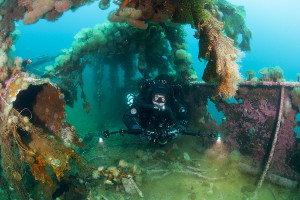
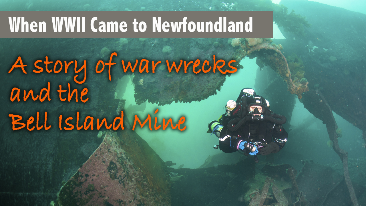
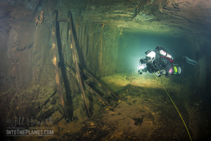
Beneath Bell Island, hundreds of kilometers of mine tunnels weave below the sea floor of Conception Bay, where the WWII wrecks reside. Abandoned in 1966, these mine passages are now flooded. Early exploration has uncovered a trove of artifacts, revealing the cultural history of mining. When the doors were shuttered, there was no inventory of assets. The tunnels contain mining relics, pipes, heavy equipment and remarkable inscriptions, telling the story of miners who died during their work on Bell Island.

PRINCE EDWARD ISLAND

Read the Toronto Star Feature about Climate Change: Will PEI disappear beneath the waves?

Emily Pope from Diversified Divers Inc./Divers Quarters recommends these shore dives:
White Eagles, Cavendish, PEI
– Depth: 15-20 ft
– Rocky bottom with lobster, flounder, ocean perch, eel, winter skate

Tracadie Beach, Tracadie Harbour, PEI
– Depth: 10-15 ft
– Sandy/Grassy bottom with lobster, crabs, flounder, American eel,
northern pipefish, hermit crabs, and perch

Panmure Ledge, Panmure Island, PEI
– Depth: 10-18 ft
– Sandy bottom with rocky ledge with lobster, flounder, crabs

Seal River Bridge, Cardigan, PEI
– Depth 20-22 ft
– Sand/silt bottom to rock/shell bottom with lobster, flounder, crabs,
sponges and perch

If you want to get out on a boat check out her website!

QUEBEC

Following the St. Lawrence River to the Atlantic, Quebec offers divers a chance to get off the beaten path into colourful underwater landscapes peppered with macro life and elusive megafauna like humpback whales and rare populations of belugas and seals. Temperatures are much chillier than Ontario’s stretch of the St. Lawrence. Divers need to be prepared for near-freezing conditions. It is worth a trek to dive with local guides who will show you the very best of places like the Saguenay Fjord and legendary wrecks such as the Empress of Ireland.

ONTARIO

KellyRizzo9296l
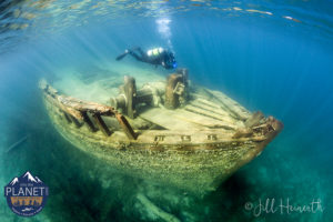
FATHOM FIVE NATIONAL MARINE PARK: The wreck of the Sweepstakes lays in Big Tub Harbour in Tobermory at Fathom Five Underwater National Marine Park.

Located in Lake Huron, the National Marine Conservation Area seeks to protect the regions lighthouses and shipwrecks as well as offer a conservation zone for freshwater ecosystems. The park is one of Canada’s most popular scuba diving locations and glass bottom boat tours offers visitors a chance to see some wrecks without even getting wet. Many visitors camp at nearby Bruce Peninsula National Park as well as hike the many trails along the Niagara Escarpment.

MANITOBA

Riding Mountain National Park – Crystal spring waters of Clear Lake provide ample opportunity for diving. The deepest point in the lake is approximately 34.7 m (114 feet) deep. Divers must register for their dives by contacting the Park at 204-848-7275 prior to completing any dives in the park.

West Hawk Lake, Manitoba – A meteor strike caused the formation of West Hawk Lake. This beautiful Manitoba lake is known for great beaches and is over 100 m (300 feet) deep, Look for plentiful smallmouth bass.

Duck Mountain Provincial Park, East Blue Lake – This lake is popular due to the fact that locals report seeing bottom 40 feet below their boats. The depth is reported as 180 feet.

NORTHWEST TERRITORIES

Shit I Found in Yellowknife – Jeremy MacDonald’s Mission

Arsenic and Gold Flakes – How Dene Storytellers will Help Save Descendents from Arsenic Poisoning

SASKATCHEWAN

Whiteswan Lake, Saskatchewan – Explore the remnants of a flooded town that were drowned during the building of two nearby dams in 1912 and 1947. The dive begins with a surface swim of about 100 m. You will see a road, two spillways, a blockhouse, and three telephone poles. Divers have added toilets accessories and a habitat. The old abandoned town is accessible only by boat and is not clearly marked. Latitude: 54.04715 Longitude: -105.16763

Many other clear lakes in this region provide diving opportunities.

Duck Mountain Provincial Park (Saskatchewan) – Duck Mountain Provincial Park is a Saskatchewan Provincial Park, located 14 km east of the town of Kamsack and stretches some 12 kilometres eastward to the Saskatchewan/Manitoba boundary. The area represents the southern limit of the boreal forest, in its transition zone to aspen parkland. The forest is a refuge for elk, deer, moose, coyote, black bear, lynx, bobcat, and timber wolf. Fish species include walleye, yellow perch, northern pike, burbot, and white sucker. Madge Lake is the largest body of water in the park and serves as its central tourist attraction. The lake hosts a large local breeding flock of ducks and other waterfowl. There are two public swimming beaches (Ministik Beach and Pickerel Point Beach) constructed with artificially supplied sand.

Lake Diefenbaker – This popular dive spot has varying conditions. The Danielson Provincial Park and downstream of the dam are popular for diving.

YUKON

“There’s a land where the mountains are nameless, And the rivers all run God knows where…” • ROBERT W. SERVICE, THE SPELL OF THE YUKON

The Yukon Territory, like much of the rest of Canada, can boast abundant water resources, in six major watersheds: the Alsek, Yukon, Porcupine, Peel, Liard and North Slope. Wetlands, marshes, groundwater aquifers, rivers, lakes, permafrost, and nearly 1400 glaciers cover the landscape. Most of the water in the Yukon originates there and flows outward. What happens in Yukon affects others, but outside influences other than global climate change, do not flow into the territory for the most part.

As I learned in the Carcross First Nations region, water and lakes have important spiritual and cultural importance for the local people. Traditional uses of water and water rights are protected in the Yukon First Nations Final Agreements. Communities are located on important waterways and transport routes and the historic and future prosperity of people depend on access to and protection of these bodies of water.

To this end, the Yukon government partnered in developing the Yukon Water Strategy and Action Plan with the Yukon First Nation governments, transboundary First Nations, Yukon government agencies, the federal government, other provincial and territorial governments, municipalities and communities, boards and councils, non-government organizations, water researchers and consultants, the business community and individuals. The strategy paper was intended to plan for future water use and needs in the context of climate change. The document looks at population growth, agriculture, water management, infrastructure, consumptive use, and land use policy. It takes the approach of understanding that water is a shared gift and not a commodity. 

The Yukon Water Strategy and Action Plan details how the Yukon government will:

• Develop a set of principles for making decisions affecting water resources;

• Improve water research and understanding of local resources;

• Improve access to safe and affordable drinking water;

• Promote sustainability;

• Improve outreach and education about water resources;

• Improve collaboration with First Nation’s stakeholders and other government organizations

• Plan for climate change.

The City of Whitehorse, where a majority of the population is concentrated, has an aggressive biweekly drinking testing program from over 20 sites. The drinking water quality is considered excellent. But even with good management of municipal supplies, we need to look at aging infrastructure for developing issues as this CBC story revealed.

Discovering elevated lead levels in the drinking water fountains of numerous Yukon schools, the government realized that over 140 fixtures and lead pipes needed to be replaced with more modern and safer alternatives. Safeguarding our drinking water starts at the source, continues through treatment and must be assured in pathways for delivery.

While visiting Carcross, I had an opportunity to walk along the shoreline of Bennett Lake with the local Chief who explained the creation stories and importance of the lake to his people. I was pleased to have the chance to learn about local water challenges and offer my presentation, “We Are Water,” at the Dänojà Zho Cultural Centre in town. After the presentation, each young person was gifted one of my books and dozens also went home with We Are Water movies and other prizes.

BRITISH COLUMBIA

The Emerald Sea is abundant. In the cool west coast waters, giant octopus, wolf eels and Pacific White Sided Dolphins frolick with Orcas and clouds of herring. Steep plunging rock walls are covered with strawberry anemones, plump white plumose anemones and colorful sponges in bouquets of color. This is my favorite corner of the world for diving.

Swim with sea lions off Hornby Island.

Swim with jellyfish at Terra Nova National Park, NL

Learn about WWII shipwrecks

Dive under sea ice

Jump into Google Voyager

Swim with sea lions in BC

WATER STORIES

WINDOW ON CANADA

Do you want some calming Canadian content to show on your TV during a party or perhaps some subtle relaxing wild tracks to fall asleep to? These long visual wallpapers will help you unwind while exposing you to unique views across Canada.

Share Button